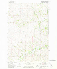
1974 Map of Odland Dam NE
USGS Topo · Published 1977About this map
Dry Beaver Creek meanders through the drainages of the high plains along the North Dakota and Montana state line in the mid-1970s. The landscape reflects a rural economy of decentralized homesteads and resource extraction, marked by a Well, a Gravel Pit, and a Scoria Pit. In the northwestern corner of the quadrangle, Elmwood and Henry are noted among the townships, while local community life is anchored by the Arvid Sch and the secluded Blue Mountain Cem. The terrain is characterized by intricate coulees and a natural Spring at the southern edge, illustrating the critical importance of water access in this high-plains region during the period of post-war agricultural stabilization.
Find a feature on this map
11 named features on this map. Tap any name to fly to it.
Don’t see what you’re looking for? This feature index may not catch every label — zoom into the map to look around manually.
Map Details
Editions of this 1974 Odland Dam NE Map
This is the sole edition of this map. No revisions or reprints were ever made.
Other maps of this area

1909 · Glendive
USGS Topo · 1:250,000

1953 · Watford City
USGS Topo · 1:250,000

1954 · Glendive
USGS Topo · 1:250,000

1957 · Glendive
USGS Topo · 1:250,000

1957 · Watford City
USGS Topo · 1:250,000

1958 · Glendive
USGS Topo · 1:250,000

1967 · Watford City
USGS Topo · 1:250,000

1974 · Hootowl Creek West
USGS Topo · 1:24,000

1974 · Trotters
USGS Topo · 1:24,000
1974 · Skaar
USGS Topo · 1:24,000