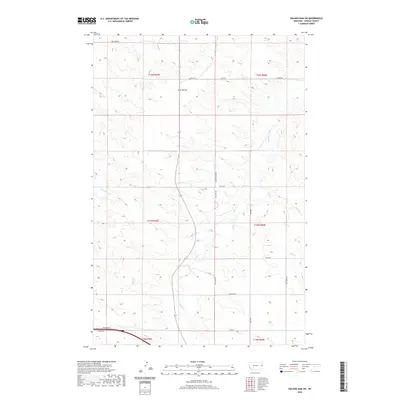
2020 Map of Odland Dam SW
USGS Topo · Published 2020About this map
Four Buttes rise as a distinctive landform in this section of Wibaux County, marking the high ground between several drainage basins. The landscape is defined by the winding course of Beaver Cr, which runs centrally through the quadrangle, flanked by smaller tributaries like Box Elder Cr and Hay Cr. This modern survey by the U.S. Geological Survey details a sparse, ranching-oriented network of local roads and section lines that have persisted for generations. Named routes such as Lone Tree Rd, Log Cabin Rd, and Ohnstad Rd reflect the homesteading history and local family legacy of eastern Montana. In the southern portion, the presence of Frontage Rd and Tunnel Rd indicates the primary transportation corridor through this prairie terrain, where the infrastructure follows the natural contours of the northern plains.
Find a feature on this map
26 named features on this map. Tap any name to fly to it.
Don’t see what you’re looking for? This feature index may not catch every label — zoom into the map to look around manually.
Map Details
Editions of this 2020 Odland Dam SW Map
This is the sole edition of this map. No revisions or reprints were ever made.
Other maps of this area

1909 · Glendive
USGS Topo · 1:250,000

1953 · Miles City
USGS Topo · 1:250,000

1954 · Glendive
USGS Topo · 1:250,000

1957 · Miles City
USGS Topo · 1:250,000

1957 · Glendive
USGS Topo · 1:250,000

1958 · Miles City
USGS Topo · 1:250,000

1958 · Glendive
USGS Topo · 1:250,000
1974 · Odland Dam
USGS Topo · 1:24,000
1974 · Odland Dam NE
USGS Topo · 1:24,000

1981 · Glendive
USGS Topo · 1:100,000