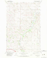
1982 Map of Odland Dam SW
USGS Topo · Published 1983About this map
Four Buttes rises as a prominent landmark in the high plains of Wibaux County, overlooking a landscape defined by the winding course of Beaver Creek. This 1982 survey reveals a rural territory where water management and livestock grazing dictated the placement of numerous scattered wells and small reservoirs. The eastern portion of the quadrangle is drained by Hay Creek and its tributary, East Branch, cutting through the rolling terrain. Human activity is evidenced by small industrial footprints such as a Gravel Pit and several Gravel Pits, which provided the necessary materials for the network of improved and unimproved roads connecting this area to distant centers like Wibaux and Sidney. The map documents the persistent ranching character of the Montana borderlands before modern consolidation, tracing fence lines and section boundaries across the prairie.
Find a feature on this map
7 named features on this map. Tap any name to fly to it.
Don’t see what you’re looking for? This feature index may not catch every label — zoom into the map to look around manually.
Map Details
Editions of this 1982 Odland Dam SW Map
This is the sole edition of this map. No revisions or reprints were ever made.
Other maps of this area

1909 · Glendive
USGS Topo · 1:250,000

1953 · Miles City
USGS Topo · 1:250,000

1954 · Glendive
USGS Topo · 1:250,000

1957 · Miles City
USGS Topo · 1:250,000

1957 · Glendive
USGS Topo · 1:250,000

1958 · Miles City
USGS Topo · 1:250,000

1958 · Glendive
USGS Topo · 1:250,000
1974 · Odland Dam
USGS Topo · 1:24,000
1974 · Odland Dam NE
USGS Topo · 1:24,000

1981 · Glendive
USGS Topo · 1:100,000