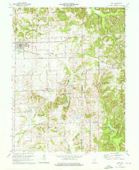
1974 Map of Odon
USGS Topo · Published 1976About this map
Odon serves as the primary hub of this landscape at the intersection of Daviess and Martin counties, where the Chicago Milwaukee St Paul and Pacific railroad cuts across the agricultural plains. The map reveals a dense network of rural community landmarks, particularly south of town in Van Buren township. Here, the landscape transitions from the flatlands near Prairie Creek into the more varied terrain of Hickory Ridge.
Find a feature on this map
33 named features on this map. Tap any name to fly to it.
Don’t see what you’re looking for? This feature index may not catch every label — zoom into the map to look around manually.
Map Details
Editions of this 1974 Odon Map
2 editions found
Other maps of this area

1943 · Lyons
USGS Topo · 1:24,000

1943 · Epsom
USGS Topo · 1:24,000

1944 · Montgomery
USGS Topo · 1:24,000

1950 · Shoals
USGS Topo · 1:24,000

1950 · Odon
USGS Topo · 1:24,000

1956 · Loogootee
USGS Topo · 1:24,000

1956 · Koleen
USGS Topo · 1:24,000

1956 · Indian Springs
USGS Topo · 1:24,000

1956 · Vincennes
USGS Topo · 1:250,000

1957 · Vincennes
USGS Topo · 1:250,000