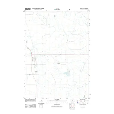
2012 Map of Oelrichs
USGS Topo · Published 2012About this map
Limestone Butte and the adjacent Limestone Butte Reservoir dominate the central landscape of this South Dakota quadrangle, where the High Plains terrain is etched by an intricate network of seasonal drainages. The settlement of Oelrichs is represented by its street grid, including Main St, Walnut St, and Elm St, which anchor the local community near the intersection of several regional routes. The surrounding country is defined by watercourses like Horsehead Cr and the various branches of Blacktail Creek, including N Fork Blacktail Cr and S Fork Blacktail Cr. Prominent elevations such as Windy Butte and the depression of Antelope Hollow provide clear navigational landmarks for those studying the physical geography of Fall River County during this era.
Find a feature on this map
19 named features on this map. Tap any name to fly to it.
Don’t see what you’re looking for? This feature index may not catch every label — zoom into the map to look around manually.
Map Details
Editions of this 2012 Oelrichs Map
This is the sole edition of this map. No revisions or reprints were ever made.
Other maps of this area

1896 · Oelrichs
USGS Topo · 1:125,000

1900 · Oelrichs
USGS Topo · 1:125,000

1950 · Hot Springs SE
USGS Topo · 1:24,000

1955 · Hot Springs
USGS Topo · 1:250,000
1982 · Smithwick
USGS Topo · 1:25,000
1982 · Oelrichs SW
USGS Topo · 1:25,000
1982 · Heinne Creek
USGS Topo · 1:25,000
1982 · Black Banks Creek East
USGS Topo · 1:24,000
1982 · Hay Canyon Butte
USGS Topo · 1:25,000
1982 · Lone Well Creek East
USGS Topo · 1:24,000