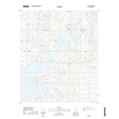
2018 Map of Ofelia
USGS Topo · Published 2018About this map
The Tallapoosa River and its intricate shoreline dominate this modern topographic survey, showing the impact of the R L Harris Reservoir on the local landscape. The map captures a mix of established rural settlements like Ofelia and Swagg alongside more recent lakeside developments. For genealogists and local historians, several burial sites remain clearly marked, including Pleasant Hill Cem, Shake Rag Cem, and Boozer Cem, offering clues to long-standing family ties in the area.
Find a feature on this map
103 named features on this map. Tap any name to fly to it.
Don’t see what you’re looking for? This feature index may not catch every label — zoom into the map to look around manually.
Map Details
Editions of this 2018 Ofelia Map
This is the sole edition of this map. No revisions or reprints were ever made.
Other maps of this area

1891 · Ashland
USGS Topo · 1:125,000

1899 · Wedowee
USGS Topo · 1:125,000

1902 · Wedowee
USGS Topo · 1:125,000

1953 · Atlanta
USGS Topo · 1:250,000

1957 · Atlanta
USGS Topo · 1:250,000

1958 · Atlanta
USGS Topo · 1:250,000

1969 · Wadley North
USGS Topo · 1:24,000
1969 · Newell
USGS Topo · 1:24,000
1969 · Wedowee
USGS Topo · 1:24,000

1969 · Mellow Valley
USGS Topo · 1:24,000