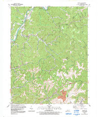
1992 Map of Offutt
USGS Topo · Published 1992About this map
The Levisa Fork carves a path through the northeastern Kentucky hills, anchoring a landscape defined by its deep coal-mining and natural gas heritage. This 1990s-era study documents the traditional settlements and narrow hollows of Johnson County and Martin County, including the coal-town history of Van Lear and Boons Camp. The presence of an extensive Gas Field and numerous labeled Mines and a Mine Dump near the Big Sandy Regional Airport reflects the industrial activity of the Cumberland Plateau. Local genealogy is well-preserved through family-named landmarks such as the Ward Cem and rural institutions like Wells Chapel and Meade Memorial High Sch. These features, along with names like Butcher Hollow and Pigeonroost Branch, illustrate the area's intricate network of waterways and small-scale community sites that have persisted through the late twentieth century.
Find a feature on this map
57 named features on this map. Tap any name to fly to it.
Don’t see what you’re looking for? This feature index may not catch every label — zoom into the map to look around manually.
Map Details
Editions of this 1992 Offutt Map
This is the sole edition of this map. No revisions or reprints were ever made.
Other maps of this area

1886 · Prestonsburg
USGS Topo · 1:125,000

1892 · Prestonsburg
USGS Topo · 1:125,000

1914 · Laynesville
USGS Topo · 1:48,000

1914 · Inez
USGS Topo · 1:48,000

1915 · Paintsville
USGS Topo · 1:48,000

1915 · Prestonsburg
USGS Topo · 1:62,500

1916 · Harold
USGS Topo · 1:62,500

1916 · Inez
USGS Topo · 1:62,500

1917 · Paintsville
USGS Topo · 1:62,500

1918 · Prestonsburg
USGS Topo · 1:62,500