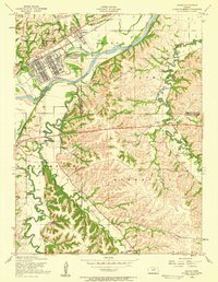
1955 Map of Ogden
USGS Topo · Published 1958About this map
The Kansas River cuts a wide path through the northern half of this mid-century landscape, separating the military installations of Fort Riley Military Reservation from the rural townships of Ashland and Wingfield. The town of Ogden sits just north of the river, while the grid-like complex of Camp Funston dominates the northern bank with its barracks, swimming pools, and the Funston Monument. This area shows the heavy influence of the Union Pacific railroad corridor as it follows the river valley, serving as a primary transit artery for the region.
Find a feature on this map
40 named features on this map. Tap any name to fly to it.
Don’t see what you’re looking for? This feature index may not catch every label — zoom into the map to look around manually.
Map Details
Editions of this 1955 Ogden Map
3 editions found
Other maps of this area

1886 · Junction City
USGS Topo · 1:125,000

1889 · Junction City
USGS Topo · 1:125,000

1889 · Parkerville
USGS Topo · 1:125,000

1894 · Junction City
USGS Topo · 1:125,000

1894 · Parkerville
USGS Topo · 1:125,000

1947 · Manhattan
USGS Topo · 1:62,500

1947 · Fort Riley
USGS Topo · 1:62,500

1950 · Keats
USGS Topo · 1:24,000

1950 · Manhattan
USGS Topo · 1:24,000

1950 · Junction City
USGS Topo · 1:24,000