
1970 Map of Ogema
USGS Topo · Published 1972About this map
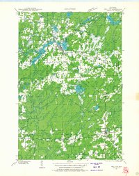
Ogema serves as the central hub of this 1970s survey, situated where the Ogema Millpond and several county roads converge near the boundary between Price and Taylor counties. The landscape is a network of small glacial lakes and wetlands, drained by the South Fork Jump River and Douglas Creek. These water systems supported the local economy, evident in the drainage patterns near the Sewage Disposal Ponds and the clustered settlements of Centerville and Ottertail Springs.
Find a feature on this map
48 named features on this map. Tap any name to fly to it.
Don’t see what you’re looking for? This feature index may not catch every label — zoom into the map to look around manually.
Map Details
Editions of this 1970 Ogema Map
This is the sole edition of this map. No revisions or reprints were ever made.
Other maps of this area
1941 · Phillips
USGS Topo · 1:48,000

1941 · Brantwood
USGS Topo · 1:48,000
1943 · Philliips
USGS Topo · 1:48,000
1943 · Brantwood
USGS Topo · 1:48,000

1944 · Ogema
USGS Topo · 1:48,000

1945 · Rib Lake
USGS Topo · 1:48,000

1947 · Rib Lake
USGS Topo · 1:48,000

1947 · Ogema
USGS Topo · 1:48,000
1949 · Ogema
USGS Topo · 1:48,000

1949 · Rib Lake
USGS Topo · 1:48,000