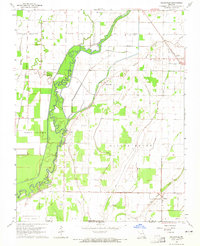
1964 Map of Oglesville
USGS Topo · Published 1965About this map
The Black River dominates this landscape, winding through a complex network of sloughs and ditches that speak to the historical drainage and reclamation efforts along the Butler and Clay County line. Small communities and landmarks like Oglesville, Carola, and Fagus are positioned at the margins of the low-lying wetlands, often sheltered by topographic rises like Gillis Bluff or Melville Ridge. The presence of an Old Railroad Grade and numerous water control features, such as Little Caney Ditch and the Pumping Station, illustrates the mid-century transition from a seasonal flood-plain into an engineered agricultural landscape.
Find a feature on this map
32 named features on this map. Tap any name to fly to it.
Don’t see what you’re looking for? This feature index may not catch every label — zoom into the map to look around manually.
Map Details
Editions of this 1964 Oglesville Map
2 editions found
Other maps of this area

1935 · Rector
USGS Topo · 1:62,500

1935 · Harviell
USGS Topo · 1:62,500

1940 · Valley Ridge
USGS Topo · 1:62,500

1940 · Piggott
USGS Topo · 1:62,500

1956 · Valley Ridge
USGS Topo · 1:62,500

1956 · Piggott
USGS Topo · 1:62,500

1957 · Poplar Bluff
USGS Topo · 1:250,000

1958 · Rector
USGS Topo · 1:62,500

1959 · Poplar Bluff
USGS Topo · 1:250,000
1960 · Rector
USGS Topo · 1:62,500