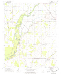
1964 Map of Oglesville
USGS Topo · Published 1977About this map
The Black River meanders across this mid-1960s landscape, defining the topography of the border between Missouri and Arkansas. The settlement of Qulin sits at a transportation nexus in the northeast, while the smaller communities of Oglesville and Carola occupy higher ground near the river's winding course. The lowlands are marked by numerous sloughs and ridges, such as Menorkenut Ridge and Menorkenut Slough, reflecting the complex hydrology of the region before modern drainage patterns were fully established. Rural life is anchored by institutions like Black River Ch and Calvary Ch, along with local burial grounds including Kelly Cem and Carola Cem. In the southeast, the small town of Fagus lies near Fish Trap Slough, just north of the Missouri Arkansas line, where an Old Railroad Grade hints at the area's former timber or transit infrastructure.
Find a feature on this map
30 named features on this map. Tap any name to fly to it.
Don’t see what you’re looking for? This feature index may not catch every label — zoom into the map to look around manually.
Map Details
Editions of this 1964 Oglesville Map
2 editions found
Other maps of this area

1935 · Rector
USGS Topo · 1:62,500

1935 · Harviell
USGS Topo · 1:62,500

1940 · Valley Ridge
USGS Topo · 1:62,500

1940 · Piggott
USGS Topo · 1:62,500

1956 · Valley Ridge
USGS Topo · 1:62,500

1956 · Piggott
USGS Topo · 1:62,500

1957 · Poplar Bluff
USGS Topo · 1:250,000

1958 · Rector
USGS Topo · 1:62,500

1959 · Poplar Bluff
USGS Topo · 1:250,000
1960 · Rector
USGS Topo · 1:62,500