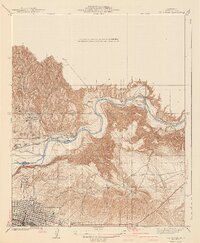
1940 Map of Oil Center
USGS Topo · Published 1940About this map
Oil Center and the neighboring industrial hubs of Oil City and Treadwell dominate the high ground north of the Kern River in this detailed 1940 edition. The landscape is defined by the heavy infrastructure of the era's petroleum industry, with a dense network of roads and pipelines giving way to the expanding grid of Bakersfield at the southern edge of the sheet. Education and social services are prominently marked, including the Petroleum Sch, Aztec Sch, and Toltec Sch, alongside the County Hospital. Water management for the valley's development is evident through the Beardsley Canal and China Grade Canal, while the Southern Pacific railroad provides the essential transport link for the region's mineral wealth. In the east, the sharp elevation of Ant Hill rises above the river, providing a stark contrast to the organized industrial activity of the western oil fields.
Find a feature on this map
25 named features on this map. Tap any name to fly to it.
Don’t see what you’re looking for? This feature index may not catch every label — zoom into the map to look around manually.
Map Details
Editions of this 1940 Oil Center Map
2 editions found
Other maps of this area

1906 · Bakersfield
USGS Topo · 1:62,500

1910 · Buena Vista Lake
USGS Topo · 1:125,000

1912 · Buena Vista Lake
USGS Topo · 1:125,000

1914 · Caliente
USGS Topo · 1:125,000

1929 · Fairfax School
USGS Topo · 1:31,680

1930 · Oildale
USGS Topo · 1:31,680

1931 · Edison
USGS Topo · 1:31,680

1932 · North of Oildale
USGS Topo · 1:31,680

1932 · Fairfax School
USGS Topo · 1:31,680
1932 · Gosford
USGS Topo · 1:31,680