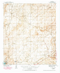
1943 Map of Oil City
USGS Topo · Published 1984About this map
Oil City serves as the focal point for this section of southeastern New Mexico, surveyed in the years preceding World War II. The landscape is defined by a sparse but deliberate network of water sources and family operations, including the North Williams Ranch, Millman Ranch, and Benson Ranch. These outposts are connected by various draws, such as Chalk Bluff Draw and Palmilla Draw, which carve through the arid terrain of Burro Flat and the Clayton Basin.
Find a feature on this map
32 named features on this map. Tap any name to fly to it.
Don’t see what you’re looking for? This feature index may not catch every label — zoom into the map to look around manually.
Map Details
Editions of this 1943 Oil City Map
Other maps of this area

1939 · Carlsbad
USGS Topo · 1:62,500

1939 · Nash Draw
USGS Topo · 1:62,500

1942 · Clayton Basin
USGS Topo · 1:62,500

1943 · Carlsbad
USGS Topo · 1:62,500

1943 · Clayton Basin
USGS Topo · 1:62,500

1943 · Oil City
USGS Topo · 1:62,500

1943 · Nash Draw
USGS Topo · 1:62,500

1943 · West Carlsbad
USGS Topo · 1:62,500

1945 · West Carlsbad
USGS Topo · 1:62,500

1954 · Carlsbad
USGS Topo · 1:250,000