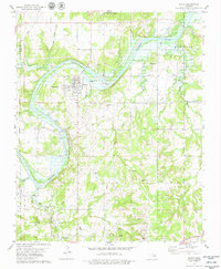
1978 Map of Oilton
USGS Topo · Published 1979About this map
The Cimarron River winds through this landscape, marking the historical boundary between the Oklahoma Territory and Indian Territory. The region is defined by its industrial heritage, dominated by the Tiger Oil Field and the Olive Oil Field, where numerous oil wells and quarries dot the terrain. The town of Oilton stands as a central hub near the shores of Keystone Lake, while the smaller settlements of Drumright, Pemeta, and Crow are connected by a network of roads and the visible Old Railroad Grade. Local history is preserved in several rural burial grounds, including North Highland Cem and Brooks Cem. Significant landmarks such as Monitor Hill and the Cimarron Valley Ch provide geographic and community anchors in an area where the extraction economy shaped the settlement patterns of Creek and Payne Counties.
Find a feature on this map
31 named features on this map. Tap any name to fly to it.
Don’t see what you’re looking for? This feature index may not catch every label — zoom into the map to look around manually.
Map Details
Editions of this 1978 Oilton Map
This is the sole edition of this map. No revisions or reprints were ever made.
Other maps of this area

1901 · Nuyaka
USGS Topo · 1:125,000

1912 · Hominy
USGS Topo · 1:125,000

1915 · Hominy
USGS Topo · 1:125,000

1916 · Bristow
USGS Topo · 1:62,500

1929 · Yale
USGS Topo · 1:62,500

1931 · Drumright
USGS Topo · 1:62,500

1932 · Yale
USGS Topo · 1:62,500

1954 · Oklahoma City
USGS Topo · 1:250,000

1955 · Enid
USGS Topo · 1:250,000

1957 · Oklahoma City
USGS Topo · 1:250,000