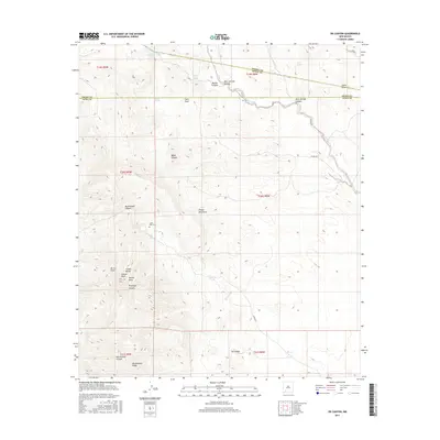
2017 Map of OK Canyon
USGS Topo · Published 2017About this map
Cookes Peak rises as the dominant landmark of this high-desert landscape, anchoring the southern end of the Cookes Range. The presence of the Cooks Peak Cem near Riley Spring points to a history of habitation and prospecting in this mineral-rich region of New Mexico. The terrain is deeply incised by a network of drainages, including Ok Canyon, Montezuma Canyon, and Provinger Canyon, which fall away from the central highlands toward the surrounding basins. Water sources such as Walnut Spring and Shale Spring suggest the critical importance of reliable springs for travelers and early settlers navigating this arid environment. The map also delineates the complex jurisdictional boundaries where Grant Co, Luna Co, and Sierra Co meet, reflecting the historical division of these rugged territories.
Find a feature on this map
37 named features on this map. Tap any name to fly to it.
Don’t see what you’re looking for? This feature index may not catch every label — zoom into the map to look around manually.
Map Details
Editions of this 2017 OK Canyon Map
This is the sole edition of this map. No revisions or reprints were ever made.
Other maps of this area
1899 · Deming
USGS Topo · 1:125,000
1915 · Deming
USGS Topo · 1:125,000
1955 · Las Cruces
USGS Topo · 1:250,000
1956 · Dwyer
USGS Topo · 1:62,500
1958 · Las Cruces
USGS Topo · 1:250,000
1962 · Lake Valley
USGS Topo · 1:62,500
1964 · Goat Ridge
USGS Topo · 1:24,000
1964 · Florida
USGS Topo · 1:24,000
1964 · Massacre Peak
USGS Topo · 1:24,000
1982 · Hatch
USGS Topo · 1:100,000