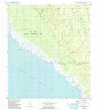
1954 Map of Okefenokee Slough
USGS Topo · Published 1993About this map
The Gulf of Mexico shoreline in Taylor County defines this mid-century survey, where the low-lying coastal marshes meet the Big Bend Wildlife Management Area. This landscape is shaped by intricate tidal networks and freshwater drainage systems, including Okefenokee Slough and Warrior Creek. Human presence is concentrated in small coastal outposts and hunting or fishing stations such as Spring Warrior Camp, Yates Camp, and Jabo Camp.
Find a feature on this map
26 named features on this map. Tap any name to fly to it.
Don’t see what you’re looking for? This feature index may not catch every label — zoom into the map to look around manually.
Map Details
Editions of this 1954 Okefenokee Slough Map
2 editions found
Other maps of this area

1954 · Warrior Swamp
USGS Topo · 1:24,000

1954 · Hampton Springs
USGS Topo · 1:24,000

1954 · Keaton Beach
USGS Topo · 1:24,000

1954 · Okefenokee Slough
USGS Topo · 1:24,000

1954 · Gainesville
USGS Topo · 1:250,000

1954 · Valdosta
USGS Topo · 1:250,000

1955 · Perry
USGS Topo · 1:24,000

1955 · Rock Islands
USGS Topo · 1:24,000

1955 · Manlin Hammock
USGS Topo · 1:24,000
1956 · Hampton Springs
USGS Topo · 1:25,000