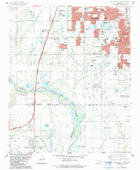
1986 Map of Oklahoma City SE
USGS Topo · Published 1986About this map
The Canadian River serves as the dividing line between Oklahoma City, Moore, and Newcastle in this mid-1980s landscape of rapid suburban expansion and active resource extraction. Residential growth is visible in the dense clusters of schools like Kingsgate Sch and Plaza Towers Sch, alongside significant local landmarks such as Resthaven Gardens (Cemetery) and the Earlywine Park Golf Course. This era shows a transition where the urban footprint of Oklahoma City begins to merge with its neighbors, yet the land remains defined by the Liberty Oil and Gas Field and scattered Oil Wells. Transportation infrastructure dominates the western half of the sheet, where the Southwest Expressway and the H E Bailey Turnpike Toll Road facilitate movement between the developing towns and the central city.
Find a feature on this map
62 named features on this map. Tap any name to fly to it.
Don’t see what you’re looking for? This feature index may not catch every label — zoom into the map to look around manually.
Map Details
Editions of this 1986 Oklahoma City SE Map
2 editions found
Other maps of this area

1892 · Moore
USGS Topo · 1:62,500

1893 · Norman
USGS Topo · 1:62,500

1893 · Oklahoma City
USGS Topo · 1:62,500

1898 · Purcell
USGS Topo · 1:125,000

1904 · Chickasha
USGS Topo · 1:125,000

1925 · Norman NO 2
USGS Topo · 1:24,000

1934 · Crutcho Creek
USGS Topo · 1:24,000

1934 · Moore
USGS Topo · 1:62,500

1936 · Norman
USGS Topo · 1:62,500

1938 · Moore
USGS Topo · 1:62,500