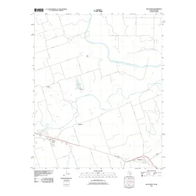
2010 Map of Oklaunion
USGS Topo · Published 2010About this map
The confluence of the Pease River and the Red River defines this north Texas landscape, where the state border follows the winding course of the latter. Near the southern edge, the settlement of Oklaunion sits along a network of roads including King St, while smaller rural clusters like Bourland and Hinds are scattered across the surrounding plains. Agriculture and water management are central to the area's development, evidenced by the Sharp Gin facility and the Claud Ayres Reservoir, which is held by the Claud Ayres Dam. These features suggest a landscape shaped by both the natural hydrology of prairie streams like Plum Creek and Dugan Creek, and the human infrastructure required to support farming. For those tracing local heritage, the Eastview Memorial Cemetery serves as a significant landmark in this Wilbarger County corridor, located west of the main town site.
Find a feature on this map
35 named features on this map. Tap any name to fly to it.
Don’t see what you’re looking for? This feature index may not catch every label — zoom into the map to look around manually.
Map Details
Editions of this 2010 Oklaunion Map
This is the sole edition of this map. No revisions or reprints were ever made.
Other maps of this area

1955 · Lawton
USGS Topo · 1:250,000

1958 · Davidson
USGS Topo · 1:62,500

1958 · Frederick
USGS Topo · 1:62,500

1958 · Vernon
USGS Topo · 1:62,500

1958 · Elmer
USGS Topo · 1:62,500

1975 · Frederick SW
USGS Topo · 1:24,000

1975 · Frederick SE
USGS Topo · 1:24,000
1983 · Boggy Creek
USGS Topo · 1:24,000
1983 · Lockett
USGS Topo · 1:24,000
1983 · Vernon
USGS Topo · 1:24,000