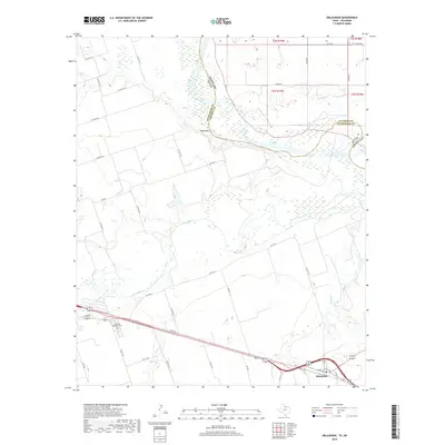
2019 Map of Oklaunion
USGS Topo · Published 2019About this map
The confluence of the Red River and Pease River dominates this portion of the Texas-Oklahoma border, defining a landscape shaped by shifting watercourses and alluvial plains. Near the southern edge, the settlement of Oklaunion sits along a transportation corridor defined by US Hwy 287 and a network of agricultural roads. The terrain is notably marked by Red Bluff, overlooking the sandy bed of the Red River where Wilbarger and Tillman counties meet. Further west, Eastview Memorial Cem serves as a significant landmark for genealogical research in this rural ranching and farming district. The map captures the complex drainage patterns of the region, including Salt Cr, Paradise Cr, and Dugan Cr, which carve through the plains toward the primary river systems.
Find a feature on this map
42 named features on this map. Tap any name to fly to it.
Don’t see what you’re looking for? This feature index may not catch every label — zoom into the map to look around manually.
Map Details
Editions of this 2019 Oklaunion Map
This is the sole edition of this map. No revisions or reprints were ever made.
Other maps of this area

1955 · Lawton
USGS Topo · 1:250,000

1958 · Davidson
USGS Topo · 1:62,500

1958 · Frederick
USGS Topo · 1:62,500

1958 · Vernon
USGS Topo · 1:62,500

1958 · Elmer
USGS Topo · 1:62,500

1975 · Frederick SW
USGS Topo · 1:24,000

1975 · Frederick SE
USGS Topo · 1:24,000
1983 · Boggy Creek
USGS Topo · 1:24,000
1983 · Lockett
USGS Topo · 1:24,000
1983 · Vernon
USGS Topo · 1:24,000