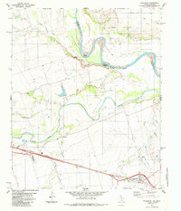
1985 Map of Oklaunion
USGS Topo · Published 1985About this map
The Red River creates a meandering border between Texas and Oklahoma in this mid-1980s landscape, characterized by the convergence of major waterways. The Pease River flows from the west to join the Red, carving through a terrain marked by features like Red Bluff. Settlement is concentrated near the Burlington Northern railroad corridor, where the town of Oklaunion serves as a local hub.
Find a feature on this map
20 named features on this map. Tap any name to fly to it.
Don’t see what you’re looking for? This feature index may not catch every label — zoom into the map to look around manually.
Map Details
Editions of this 1985 Oklaunion Map
This is the sole edition of this map. No revisions or reprints were ever made.
Other maps of this area

1955 · Lawton
USGS Topo · 1:250,000

1958 · Davidson
USGS Topo · 1:62,500

1958 · Frederick
USGS Topo · 1:62,500

1958 · Vernon
USGS Topo · 1:62,500

1958 · Elmer
USGS Topo · 1:62,500

1975 · Frederick SW
USGS Topo · 1:24,000

1975 · Frederick SE
USGS Topo · 1:24,000
1983 · Boggy Creek
USGS Topo · 1:24,000
1983 · Lockett
USGS Topo · 1:24,000
1983 · Vernon
USGS Topo · 1:24,000