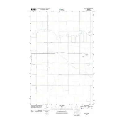
2010 Map of Oklee SW
USGS Topo · Published 2010About this map
The Lost River meanders across the northern portion of this Red Lake County landscape, joined by the southeastward flow of Hill River and the smaller Brooks Creek. This corner of northwestern Minnesota is defined by a rigorous grid of section lines and gravel paths, where county infrastructure like County Hwy-21 and County Hwy-117 connect scattered farmsteads. The eastern edge of the survey reveals localized community landmarks, including the Oklee Racetrack and the Bachand Airport. Genealogists and local historians will find the Saint Francis Xavier Cemetery located near the intersection of the primary transit corridors. The map reflects a modern rural economy still deeply tied to the land and the waterways that drain the Red River Valley basin.
Find a feature on this map
21 named features on this map. Tap any name to fly to it.
Don’t see what you’re looking for? This feature index may not catch every label — zoom into the map to look around manually.
Map Details
Editions of this 2010 Oklee SW Map
This is the sole edition of this map. No revisions or reprints were ever made.
Other maps of this area

1918 · Terrebonne
USGS Topo · 1:62,500

1919 · Grit
USGS Topo · 1:62,500

1919 · Valley
USGS Topo · 1:62,500

1952 · Grand Forks
USGS Topo · 1:250,000

1954 · Bemidji
USGS Topo · 1:250,000

1956 · Grand Forks
USGS Topo · 1:250,000

1957 · Bemidji
USGS Topo · 1:250,000

1958 · Bemidji
USGS Topo · 1:250,000
1964 · Plummer
USGS Topo · 1:24,000

1964 · Brooks
USGS Topo · 1:24,000