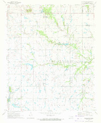
1971 Map of Okmulgee NE
USGS Topo · Published 1972About this map
Oil Field developments and agricultural land define this northeast Oklahoma landscape in the early 1970s. The terrain is marked by distinctive elevations such as Twin Hills and Bald Hill, while the local economy is illustrated by active Quarries and the petroleum infrastructure. Community life centers on several country churches and schools, notably Pumpkin Center and the cluster of Liberty Ch and Liberty Sch. This survey provides a clear look at the rural road network and small-scale civil landmarks, including the Ashley Landing Strip near Morris Lake. The presence of the Antioch Cem and various named churches like Bald Hill Ch and Antioch Ch offer significant points of interest for those researching local family history. Waterways like Little Cane Creek and Coal Creek wind through the township boundaries of Bryan and Moore, showing the drainage patterns of the Okmulgee County countryside before further modern development.
Find a feature on this map
25 named features on this map. Tap any name to fly to it.
Don’t see what you’re looking for? This feature index may not catch every label — zoom into the map to look around manually.
Map Details
Editions of this 1971 Okmulgee NE Map
2 editions found
Other maps of this area

1896 · Okmulgee
USGS Topo · 1:125,000

1900 · Okmulgee
USGS Topo · 1:125,000

1946 · Fort Smith
USGS Topo · 1:250,000

1965 · Fort Smith
USGS Topo · 1:250,000

1967 · Fort Smith
USGS Topo · 1:250,000
1970 · Council Hill
USGS Topo · 1:24,000
1970 · Morris
USGS Topo · 1:24,000
1971 · Okmulgee South
USGS Topo · 1:24,000
1971 · Spanish Peak
USGS Topo · 1:24,000
1971 · Boynton
USGS Topo · 1:24,000