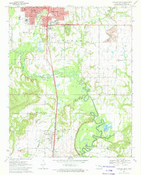
1971 Map of Okmulgee South
USGS Topo · Published 1972About this map
The St Louis San Francisco railroad corridor serves as the primary north-south artery through this Okmulgee County landscape, connecting the urban center of Okmulgee with the southern settlement of Schulter. The terrain is defined by the winding course of the Deep Fork river, which meanders through a wide floodplain dotted with oxbows like Thousand Acre Lake. To the west, the topography rises into the Tiger Hills, anchored by the prominent Elephant Knob.
Find a feature on this map
43 named features on this map. Tap any name to fly to it.
Don’t see what you’re looking for? This feature index may not catch every label — zoom into the map to look around manually.
Map Details
Editions of this 1971 Okmulgee South Map
This is the sole edition of this map. No revisions or reprints were ever made.
Other maps of this area

1896 · Okmulgee
USGS Topo · 1:125,000

1900 · Canadian
USGS Topo · 1:125,000

1900 · Wewoka
USGS Topo · 1:125,000

1900 · Okmulgee
USGS Topo · 1:125,000

1901 · Nuyaka
USGS Topo · 1:125,000

1946 · Fort Smith
USGS Topo · 1:250,000

1954 · Oklahoma City
USGS Topo · 1:250,000

1957 · Oklahoma City
USGS Topo · 1:250,000

1962 · Henryetta
USGS Topo · 1:24,000

1962 · Hoffman
USGS Topo · 1:24,000