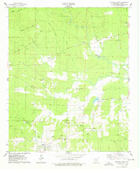
1975 Map of Okolona North
USGS Topo · Published 1978About this map
Okolona anchors the southwestern portion of this Clark County survey, reflecting a rural landscape defined by its cemeteries and watercourses during the mid-1970s. Numerous family and community burial sites, including Peeples Cem, Ross Cem, and Wier Cem, are scattered across the terrain, offering significant value for genealogical research. The Missouri Pacific railroad cuts through the southern section, serving the Kathleen Siding and highlighting the area's historical reliance on rail transport.
Find a feature on this map
44 named features on this map. Tap any name to fly to it.
Don’t see what you’re looking for? This feature index may not catch every label — zoom into the map to look around manually.
Map Details
Editions of this 1975 Okolona North Map
This is the sole edition of this map. No revisions or reprints were ever made.
Other maps of this area

1901 · Gurdon
USGS Topo · 1:125,000

1943 · Antoine
USGS Topo · 1:62,500

1953 · El Dorado
USGS Topo · 1:250,000

1955 · Little Rock
USGS Topo · 1:250,000

1956 · Little Rock
USGS Topo · 1:250,000

1957 · El Dorado
USGS Topo · 1:250,000

1958 · El Dorado
USGS Topo · 1:250,000

1960 · El Dorado
USGS Topo · 1:250,000

1960 · Little Rock
USGS Topo · 1:250,000

1964 · Little Rock
USGS Topo · 1:250,000