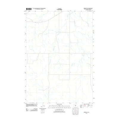
2012 Map of Okreek SE
USGS Topo · Published 2012About this map
Oak Creek flows across the northern reach of this Todd County landscape, which is defined by the branching drainage systems that eventually feed the regional river networks. The terrain is characterized by the intricate path of White Horse Creek, which splits into distinct eastern and western tributaries, known as E White Horse Creek and W White Horse Creek. These watercourses carve through the open plains, reflecting a quiet, rural geography where natural drainage patterns dictate the layout of the local road grid. The presence of these creeks suggests a prairie environment where water access was historically central to the development of the surrounding rangeland.
Find a feature on this map
4 named features on this map. Tap any name to fly to it.
Don’t see what you’re looking for? This feature index may not catch every label — zoom into the map to look around manually.
Map Details
Editions of this 2012 Okreek SE Map
This is the sole edition of this map. No revisions or reprints were ever made.
Other maps of this area

1955 · Martin
USGS Topo · 1:250,000

1958 · Martin
USGS Topo · 1:250,000

1982 · Hidden Timber
USGS Topo · 1:24,000

1982 · Okreek
USGS Topo · 1:25,000

1982 · Witten SW
USGS Topo · 1:25,000

1982 · Okreek SE
USGS Topo · 1:24,000
1982 · Keyapaha NW
USGS Topo · 1:24,000
1982 · Carter
USGS Topo · 1:25,000

1982 · Mosher
USGS Topo · 1:25,000
1982 · Hidden Timber NE
USGS Topo · 1:24,000