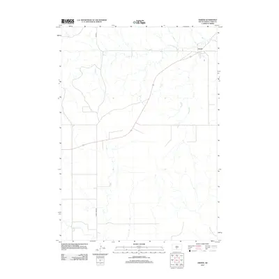
2012 Map of Okreek
USGS Topo · Published 2012About this map
The settlement of Okreek serves as a focal point in this portion of the Antelope Segment within Todd County, situated where the high prairie is carved by a network of drainage systems. The landscape is defined by the winding paths of Oak Cr in the north and Antelope Cr in the south, highlighting the essential role of water in shaping South Dakota's geography. Connectivity across this rural expanse is facilitated by a grid of thoroughfares, most notably Wood Rd and Hidden Timber Rd, which link the isolated homesteads and ranching tracts. Smaller tributaries like Butte Cr intersect the terrain, illustrating the intricate natural irrigation patterns that support the region's agricultural character.
Find a feature on this map
6 named features on this map. Tap any name to fly to it.
Don’t see what you’re looking for? This feature index may not catch every label — zoom into the map to look around manually.
Map Details
Editions of this 2012 Okreek Map
This is the sole edition of this map. No revisions or reprints were ever made.
Other maps of this area

1955 · Martin
USGS Topo · 1:250,000

1958 · Martin
USGS Topo · 1:250,000

1982 · Mission NE
USGS Topo · 1:24,000

1982 · Olsonville
USGS Topo · 1:24,000

1982 · Hidden Timber
USGS Topo · 1:24,000

1982 · Okreek
USGS Topo · 1:25,000

1982 · Okreek SE
USGS Topo · 1:24,000
1982 · Mission SE
USGS Topo · 1:24,000

1982 · Mosher
USGS Topo · 1:25,000
1982 · Hidden Timber NE
USGS Topo · 1:24,000