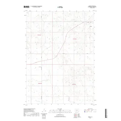
2017 Map of Okreek
USGS Topo · Published 2017About this map
Okreek stands as the primary community in this portion of the Antelope Segment, where the landscape is defined by the drainage patterns of Oak Cr and Butter Cr. The settlement is situated along a network of local thoroughfares including Wood Rd and Paulson Rd, which traverse the undulating terrain of the Rosebud Indian Reservation. To the northeast, Calvary Cem provides a focal point for genealogical interest and local history, positioned near the creek beds. In the southern half of the quadrangle, Antelope Cr flows through the sections south of Crow Dog Rd and Hidden Timber Rd. This survey documents the rural character of Todd County in the early 21st century, illustrating how modern road names and land divisions align with the historic township and range system across the Great Plains.
Find a feature on this map
15 named features on this map. Tap any name to fly to it.
Don’t see what you’re looking for? This feature index may not catch every label — zoom into the map to look around manually.
Map Details
Editions of this 2017 Okreek Map
This is the sole edition of this map. No revisions or reprints were ever made.
Other maps of this area

1955 · Martin
USGS Topo · 1:250,000

1958 · Martin
USGS Topo · 1:250,000

1982 · Mission NE
USGS Topo · 1:24,000

1982 · Olsonville
USGS Topo · 1:24,000

1982 · Hidden Timber
USGS Topo · 1:24,000

1982 · Okreek
USGS Topo · 1:25,000

1982 · Okreek SE
USGS Topo · 1:24,000
1982 · Mission SE
USGS Topo · 1:24,000

1982 · Mosher
USGS Topo · 1:25,000
1982 · Hidden Timber NE
USGS Topo · 1:24,000