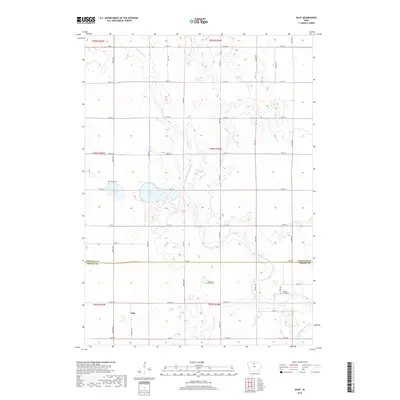
2018 Map of Olaf
USGS Topo · Published 2018About this map
Olaf sits at the intersection of Co Rd R38 and 120th St, anchoring a landscape of glacial lakes and prairie waterways in Wright County. The township is defined by the headwaters and tributaries of the West Branch Iowa River, including the meandering Eagle Cr and the upper reaches of the W Br Iowa River. Central to the geography are West Twin Lake and East Twin Lake, which provide a natural break in the structured grid of rural section roads. For those tracing family histories, this map preserves the locations of several burial sites, including West Lake Cem on the northern shore of the twins, Hickory Grove Cem to the east, and the private Simenson Family Plot. This 2018 survey illustrates the persistent agricultural and drainage patterns across the boundary of Hancock Co and Wright Co.
Find a feature on this map
27 named features on this map. Tap any name to fly to it.
Don’t see what you’re looking for? This feature index may not catch every label — zoom into the map to look around manually.
Map Details
Editions of this 2018 Olaf Map
This is the sole edition of this map. No revisions or reprints were ever made.
Other maps of this area
1954 · Mason City
USGS Topo · 1:250,000
1954 · Waterloo
USGS Topo · 1:250,000
1955 · Waterloo
USGS Topo · 1:250,000
1957 · Mason City
USGS Topo · 1:250,000
1958 · Mason City
USGS Topo · 1:250,000
1972 · Kanawha SE
USGS Topo · 1:24,000
1972 · Cornelia
USGS Topo · 1:24,000
1972 · Kanawha
USGS Topo · 1:24,000
1972 · Olaf
USGS Topo · 1:24,000
1972 · Belmond
USGS Topo · 1:24,000