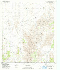
1983 Map of Old Blue Mountain
USGS Topo · Published 1992About this map
Glass Mountains dominate this high-desert landscape in Brewster County, where 1970s photogrammetric surveys capture a region defined by its water management and ranching infrastructure. Esterwood Ranch serves as a primary hub of human activity, supported by a network of windmills and catchment systems like Wallace Windmill and Frenchman Tank. The topography is a complex system of drainage and elevation, with Meeks Draw and Moose Draw cutting through the terrain between prominent peaks.
Find a feature on this map
22 named features on this map. Tap any name to fly to it.
Don’t see what you’re looking for? This feature index may not catch every label — zoom into the map to look around manually.
Map Details
Editions of this 1983 Old Blue Mountain Map
2 editions found
Other maps of this area

1923 · Hess Canyon
USGS Topo · 1:62,500

1923 · Altuda
USGS Topo · 1:62,500

1929 · Hovey
USGS Topo · 1:125,000

1954 · Fort Stockton
USGS Topo · 1:250,000

1958 · Fort Stockton
USGS Topo · 1:250,000

1973 · Fort Stockton
USGS Topo · 1:250,000

1980 · Cave Mesa
USGS Topo · 1:24,000

1980 · Hovey
USGS Topo · 1:24,000
1980 · Hovey SW
USGS Topo · 1:24,000
1983 · Gilliland Peak
USGS Topo · 1:24,000