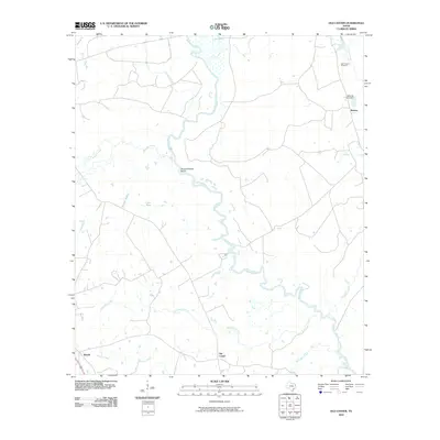
2010 Map of Old Center
USGS Topo · Published 2010About this map
The Sabine River dominates the central corridor of this Panola County landscape, winding through a complex network of wetlands and tributaries. The river's serpentine path is marked by distinctive hydrological features like Buzzard Roost Bend, while numerous drainage systems including Wilkerson Creek and Murvaul Creek feed into the river basin. The settlement pattern is sparse, concentrated at the crossroads of Old Center and the small communities of Woods and Reeves.
Find a feature on this map
16 named features on this map. Tap any name to fly to it.
Don’t see what you’re looking for? This feature index may not catch every label — zoom into the map to look around manually.
Map Details
Editions of this 2010 Old Center Map
This is the sole edition of this map. No revisions or reprints were ever made.
Other maps of this area

1945 · Socagee Bayou
USGS Topo · 1:62,500

1953 · Palestine
USGS Topo · 1:250,000

1956 · Tyler
USGS Topo · 1:250,000

1956 · Deadwood
USGS Topo · 1:62,500

1957 · Palestine
USGS Topo · 1:250,000

1958 · Center
USGS Topo · 1:62,500

1958 · Timpson
USGS Topo · 1:62,500

1958 · Carthage
USGS Topo · 1:62,500
1983 · River Hill
USGS Topo · 1:24,000
1983 · Logan
USGS Topo · 1:24,000