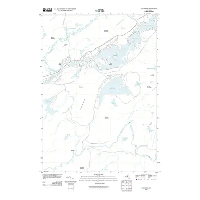
2010 Map of Old Forge
USGS Topo · Published 2010About this map
Old Forge serves as the gateway to the Fulton Chain Lakes, a region defined by its interconnected waterways and surrounding Adirondack peaks. The village is situated where the North Branch Moose River and Middle Branch Moose River converge, creating a focal point for settlement and transportation near the Old Forge Airport and Riverview Cemetery. The landscape transitions from the developed corridors along S Shore Rd to the more secluded reaches of Little Moose Lake and the private enclave at Mountain Lodge. South of the main village, the terrain rises toward McCauley Mountain and Woodhull Mountain, with the South Branch Moose River winding through remote areas like Combs Springhole. This 2010 survey illustrates the balance between recreation and wilderness, capturing the density of camps on First Lake and Second Lake alongside the protected reaches of Nicks Lake.
Find a feature on this map
70 named features on this map. Tap any name to fly to it.
Don’t see what you’re looking for? This feature index may not catch every label — zoom into the map to look around manually.
Map Details
Editions of this 2010 Old Forge Map
This is the sole edition of this map. No revisions or reprints were ever made.
Other maps of this area

1901 · Old Forge
USGS Topo · 1:62,500

1903 · Big Moose
USGS Topo · 1:62,500

1912 · Number Four
USGS Topo · 1:62,500

1912 · Mc Keever
USGS Topo · 1:62,500

1915 · Number Four
USGS Topo · 1:62,500

1950 · Utica
USGS Topo · 1:250,000

1954 · Old Forge
USGS Topo · 1:62,500

1954 · Big Moose
USGS Topo · 1:62,500

1957 · Utica
USGS Topo · 1:250,000
1957 · Number Four
USGS Topo · 1:62,500