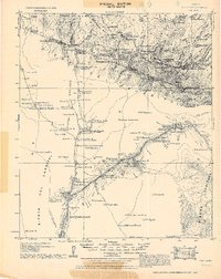
1921 Map of Old Glory
USGS Topo · Published 1929About this map
Ruby P.O. (Montana) and the Old Glory Mine anchor this tactical survey of the borderlands between Arizona and Mexico, conducted just after the First World War. The landscape is defined by the extraction economy of the Oro Blanco Mts., where mining camps like California Camp and industrial sites like the Varney's Mill (abandoned) are mapped alongside family cattle operations such as Fannon Ranch and Ranchito.
Find a feature on this map
108 named features on this map. Tap any name to fly to it.
Don’t see what you’re looking for? This feature index may not catch every label — zoom into the map to look around manually.
Map Details
Editions of this 1921 Old Glory Map
2 editions found
Other maps of this area

1904 · Patagonia
USGS Topo · 1:125,000

1905 · Patagonia
USGS Topo · 1:125,000

1905 · Nogales
USGS Topo · 1:125,000

1920 · Arivaca
USGS Topo · 1:125,000

1921 · Old Glory
USGS Topo · 1:125,000

1922 · Agus Caliente
USGS Topo · 1:62,500

1933 · Calabasas
USGS Topo · 1:62,500

1939 · Tubac
USGS Topo · 1:62,500

1941 · Presumido Peak
USGS Topo · 1:62,500

1941 · Arivaca
USGS Topo · 1:62,500