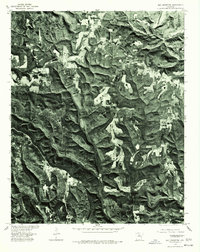
1976 Map of Old Lexington
USGS Topo · Published 1977About this map
Old Lexington and Old Botkinburg are the primary centers of settlement on this 1976 orthophotograph, which provides a direct aerial view of the Van Buren County landscape. The imagery reveals a rugged, heavily forested plateau dissected by deep drainage patterns. The Middle Fork Little Red River snakes across the northern edge of the sheet, while Archey Creek carves through the southwestern corner. The orthophoto format, produced in cooperation with the Soil Conservation Service, highlights the contrast between the dense woodland and the cleared, irregularly shaped agricultural fields that cling to the ridges and valley floors. Local connectivity is defined by winding roads such as 110, 65, and 16, which follow the natural contours of the terrain to link these isolated rural communities.
Find a feature on this map
7 named features on this map. Tap any name to fly to it.
Don’t see what you’re looking for? This feature index may not catch every label — zoom into the map to look around manually.
Map Details
Editions of this 1976 Old Lexington Map
This is the sole edition of this map. No revisions or reprints were ever made.
Other maps of this area

1892 · Marshall
USGS Topo · 1:125,000

1892 · Mountain View
USGS Topo · 1:125,000

1894 · Mountain View
USGS Topo · 1:125,000

1894 · Marshall
USGS Topo · 1:125,000

1901 · Marshall
USGS Topo · 1:125,000

1956 · Russellville
USGS Topo · 1:250,000

1963 · Leslie
USGS Topo · 1:24,000

1964 · Russellville
USGS Topo · 1:250,000
1965 · Botkinburg
USGS Topo · 1:24,000
1965 · Scotland
USGS Topo · 1:24,000