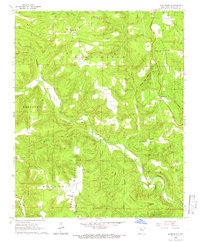
1965 Map of Botkinburg
USGS Topo · Published 1966About this map
Archey Creek carves a deep valley through the Ozark landscape of northern Van Buren County, anchoring a mid-1960s rural network of small family-named settlements and church-centered communities. This period finds Botkinburg and Rocky Hill as central points for the surrounding hills, where local life was clearly organized around landmarks like Evening Shade Ch and Salem Ch. The map reveals a high density of small cemeteries such as Arnhart Cem and Woolum Cem, offering significant detail for genealogists tracing Ozark family histories. Higher elevations are defined by Clinton Mountain and Crowell Mountain, while the presence of a Lookout Tower on Red Hill indicates the era's fire watch and communication infrastructure. The drainage patterns of North Castleberry Cr and South Castleberry Cr further illustrate the topographic complexity of the Washington and Griggs townships.
Find a feature on this map
38 named features on this map. Tap any name to fly to it.
Don’t see what you’re looking for? This feature index may not catch every label — zoom into the map to look around manually.
Map Details
Editions of this 1965 Botkinburg Map
2 editions found
Other maps of this area

1892 · Marshall
USGS Topo · 1:125,000

1892 · Mountain View
USGS Topo · 1:125,000

1894 · Mountain View
USGS Topo · 1:125,000

1894 · Marshall
USGS Topo · 1:125,000

1901 · Marshall
USGS Topo · 1:125,000

1956 · Russellville
USGS Topo · 1:250,000
1962 · Canaan
USGS Topo · 1:24,000

1963 · Leslie
USGS Topo · 1:24,000

1964 · Russellville
USGS Topo · 1:250,000
1965 · Rex
USGS Topo · 1:24,000