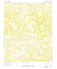
1965 Map of Botkinburg
USGS Topo · Published 1973About this map
Botkinburg serves as a small rural hub in the mid-1960s, situated at a junction near the ridgelines of Clinton Mountain and Red Hill. The landscape is defined by the winding paths of Archey Creek and its many tributaries, including Akins Creek and Copper Spring Creek, which carve deep valleys between high points like Rowell Mountain and Rocky Hill. This era shows a community structured around its spiritual and ancestral sites, with numerous country churches such as Evening Shade Ch and Salem Ch appearing alongside family-named burial grounds like Arnhart Cem and Lancelord Cem.
Find a feature on this map
38 named features on this map. Tap any name to fly to it.
Don’t see what you’re looking for? This feature index may not catch every label — zoom into the map to look around manually.
Map Details
Editions of this 1965 Botkinburg Map
2 editions found
Other maps of this area

1892 · Marshall
USGS Topo · 1:125,000

1892 · Mountain View
USGS Topo · 1:125,000

1894 · Mountain View
USGS Topo · 1:125,000

1894 · Marshall
USGS Topo · 1:125,000

1901 · Marshall
USGS Topo · 1:125,000

1956 · Russellville
USGS Topo · 1:250,000
1962 · Canaan
USGS Topo · 1:24,000

1963 · Leslie
USGS Topo · 1:24,000

1964 · Russellville
USGS Topo · 1:250,000
1965 · Rex
USGS Topo · 1:24,000