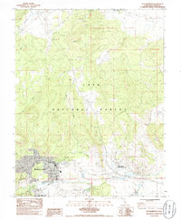
1983 Map of Old Mammoth
USGS Topo · Published 1986About this map
Mammoth Lakes serves as the focal point of this 1980s Eastern Sierra survey, showing a developing mountain community within the Inyo National Forest. The map documents the relationship between the newer resort area and the original settlement at Old Mammoth, while tracing essential infrastructure like the Fire Station, Hospital, and a Heliport. To the north, the landscape is defined by the volcanic prominence of Lookout Mountain and the water systems of Mammoth Creek and the Owens River.
Find a feature on this map
34 named features on this map. Tap any name to fly to it.
Don’t see what you’re looking for? This feature index may not catch every label — zoom into the map to look around manually.
Map Details
Editions of this 1983 Old Mammoth Map
3 editions found
Other maps of this area

1901 · Mt. Lyell
USGS Topo · 1:125,000

1914 · Mt. Morrison
USGS Topo · 1:125,000

1947 · Mariposa
USGS Topo · 1:250,000

1948 · Mariposa
USGS Topo · 1:250,000

1953 · Mt. Morrison
USGS Topo · 1:62,500

1953 · Mono Craters
USGS Topo · 1:62,500

1953 · Devils Postpile
USGS Topo · 1:62,500

1957 · Mariposa
USGS Topo · 1:250,000

1962 · Cowtrack Mtn
USGS Topo · 1:62,500

1963 · Mariposa
USGS Topo · 1:250,000