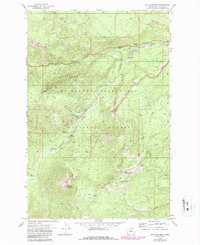
1971 Map of Old Scab Mtn.
USGS Topo · Published 1987About this map
Old Scab Mountain and Little Bald Mountain dominate this corner of the Mt Baker Snoqualmie National Forest, a landscape defined by the confluence of the American River and the Bumping River. The 1971 survey, photorevised in 1987, documents a high-altitude recreational network of campgrounds and trails before the further expansion of wilderness designations. Notable sites like American Forks Campground and Soda Springs Campground mark the access points for those navigating Fifes Ridge and the William O Douglas Wilderness. The presence of the Lookout Tower on Little Bald Mountain and a Gaging Station on the river underscores the land management priorities of the era. Water sources such as Cedar Springs and Willow Springs provided essential relief for travelers moving through the heavily forested ridges and glacial valleys of Yakima County.
Find a feature on this map
39 named features on this map. Tap any name to fly to it.
Don’t see what you’re looking for? This feature index may not catch every label — zoom into the map to look around manually.
Map Details
Editions of this 1971 Old Scab Mtn. Map
2 editions found
Other maps of this area

1901 · Snoqualmie Pass
USGS Topo · 1:125,000

1902 · Mount Aix
USGS Topo · 1:125,000

1903 · Snoqualmie
USGS Topo · 1:125,000

1904 · Mt Aix
USGS Topo · 1:125,000

1950 · Yakima
USGS Topo · 1:250,000

1957 · Wenatchee
USGS Topo · 1:250,000

1958 · Yakima
USGS Topo · 1:250,000

1961 · Yakima
USGS Topo · 1:250,000

1961 · Easton
USGS Topo · 1:62,500

1962 · Bumping Lake
USGS Topo · 1:62,500