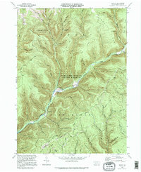
1995 Map of Oleona
USGS Topo · Published 1995About this map
Kettle Creek and Little Kettle Creek converge in the narrow valleys of this Potter County landscape, where the small settlement of Oleona serves as a central point of human activity. The map reveals a terrain heavily shaped by conservation and resource management, with most of the area lying within the Susquehannock State Forest. History is preserved at Ole Bull State Park, named for the Norwegian violinist who attempted a colony nearby. Beneath the steep slopes of Hickory Ridge and Big Ridge, the modern industrial footprint is visible through the Greenlick Gas Storage Field and Leidy Gas Storage Field. A dense network of hiking paths like the Susquehannock Trail and Swartwood Trail follows the same winding hollows and ridges used by early travelers, such as Yochum Hill Cem located on the western heights.
Find a feature on this map
63 named features on this map. Tap any name to fly to it.
Don’t see what you’re looking for? This feature index may not catch every label — zoom into the map to look around manually.
Map Details
Editions of this 1995 Oleona Map
This is the sole edition of this map. No revisions or reprints were ever made.
Other maps of this area

1943 · Hyner
USGS Topo · 1:62,500

1946 · Young Womans Creek
USGS Topo · 1:24,000

1946 · Renovo East
USGS Topo · 1:62,500

1946 · Renovo West
USGS Topo · 1:62,500

1946 · Tamarack
USGS Topo · 1:24,000

1946 · Slate Run
USGS Topo · 1:24,000

1947 · Conrad
USGS Topo · 1:62,500

1947 · Galeton
USGS Topo · 1:62,500

1947 · Lee Fire Tower
USGS Topo · 1:24,000

1947 · Short Run
USGS Topo · 1:24,000