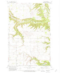
1972 Map of Olga
USGS Topo · Published 1975About this map
Olga sits at the heart of this Cavalier County landscape, where the prairie of northeastern North Dakota is deeply incised by the Little South Pembina River and the Tongue River. The terrain is defined by the sharp transition from agricultural uplands into the wooded draws of the Pembina Hills State Game Management Area, a pattern that dictated early settlement and land use. Local history and genealogy are preserved through markers such as the South Pembina Ch and Goldberg Ch, alongside a Cem that served these rural communities. The map captures the infrastructure of the early 1970s, including a Gaging Station and the Young Dam, while the presence of scattered Gravel Pits and Shale Pits indicates the region's reliance on local natural resources for building and road maintenance.
Find a feature on this map
18 named features on this map. Tap any name to fly to it.
Don’t see what you’re looking for? This feature index may not catch every label — zoom into the map to look around manually.
Map Details
Editions of this 1972 Olga Map
This is the sole edition of this map. No revisions or reprints were ever made.
Other maps of this area

1918 · Walhalla
USGS Topo · 1:62,500

1943 · Walhalla
USGS Topo · 1:62,500

1952 · Thief River Falls
USGS Topo · 1:250,000

1953 · Devils Lake
USGS Topo · 1:250,000

1956 · Thief River Falls
USGS Topo · 1:250,000

1956 · Devils Lake
USGS Topo · 1:250,000

1957 · Thief River Falls
USGS Topo · 1:250,000

1964 · Walhalla
USGS Topo · 1:24,000
1964 · Concrete
USGS Topo · 1:24,000
1964 · Hanks Corner
USGS Topo · 1:24,000