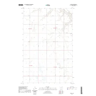
2020 Map of Olga SW
USGS Topo · Published 2020About this map
The Little Pembina River carves a winding path through the northern reaches of this Cavalier County landscape, while the Tongue River influences the hydrology of the southwestern corner. This survey of the Olga SW quadrangle captures a rural North Dakota territory defined by a rigorous section-line road grid, including Co Rd 39 and various east-west routes like 93rd St NE. For those researching local heritage or genealogy, the map identifies key burial grounds such as South Pembina Cem in the northeast and Zion Community Cem further south. The topography is marked by the subtle drainage patterns of the Red River Valley’s edge, where the seasonal movement of water across the prairie is traced in the presence of various wetlands and intermittent streams.
Find a feature on this map
21 named features on this map. Tap any name to fly to it.
Don’t see what you’re looking for? This feature index may not catch every label — zoom into the map to look around manually.
Map Details
Editions of this 2020 Olga SW Map
This is the sole edition of this map. No revisions or reprints were ever made.
Other maps of this area

1953 · Devils Lake
USGS Topo · 1:250,000

1956 · Devils Lake
USGS Topo · 1:250,000

1967 · Langdon East
USGS Topo · 1:24,000

1967 · Maida
USGS Topo · 1:24,000

1969 · Olga SW
USGS Topo · 1:24,000

1969 · Olga NW
USGS Topo · 1:24,000

1972 · Osnabrock
USGS Topo · 1:24,000
1972 · Vang
USGS Topo · 1:24,000

1972 · Easby
USGS Topo · 1:24,000
1972 · Milton
USGS Topo · 1:24,000