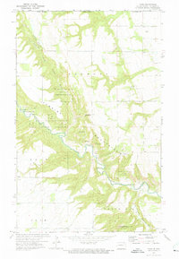
1972 Map of Vang
USGS Topo · Published 1975About this map
The Pembina Mountains dominate this 1970s landscape along the international boundary between the Canada United States border and Manitoba North Dakota line. The terrain is defined by the winding course of the Pembina River and its tributaries, including the North Pembina River and Little South Pembina River. Much of the land is dedicated to the Pembina Hills State Game Management Area, reflecting the region's conservation focus during this era. Small settlements like Vang and Boden sit near the rugged escarpment, while several named peaks such as Three Sisters Hill, Norman Otto Hill, and Old Baldy provide distinct geographic landmarks. Local industry is represented by scattered Shale Pits and gravel operations, while the Walhalla Country Club highlights the area's recreational development.
Find a feature on this map
25 named features on this map. Tap any name to fly to it.
Don’t see what you’re looking for? This feature index may not catch every label — zoom into the map to look around manually.
Map Details
Editions of this 1972 Vang Map
This is the sole edition of this map. No revisions or reprints were ever made.
Other maps of this area

1918 · Walhalla
USGS Topo · 1:62,500

1943 · Walhalla
USGS Topo · 1:62,500

1952 · Thief River Falls
USGS Topo · 1:250,000

1953 · Devils Lake
USGS Topo · 1:250,000

1956 · Thief River Falls
USGS Topo · 1:250,000

1956 · Devils Lake
USGS Topo · 1:250,000

1957 · Thief River Falls
USGS Topo · 1:250,000

1964 · Walhalla
USGS Topo · 1:24,000
1964 · Hanks Corner
USGS Topo · 1:24,000

1967 · Thief River Falls
USGS Topo · 1:250,000