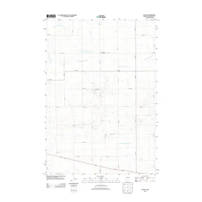
2013 Map of Olivia SE
USGS Topo · Published 2013About this map
Agricultural fields and engineered waterways define this section of Renville County, where the landscape is etched with a precise grid of rural roads and drainage canals. The natural course of Buffalo Cr winds through the center of the sheet, contrasted by the straight lines of the County Ditch Number Sixtyseven and Judicial Ditch Number Nine. These water management systems speak to the region's intensive farming heritage, transforming the prairie into productive cropland. Local history is anchored by the United Church of Hope Cem and Saint John's Lutheran Cem, which stand as quiet markers of the community's ancestral roots and religious foundations. Modern transit is represented by Us-212 cutting across the southern portion, while a network of county highways like Co Hwy-16 provides the primary infrastructure for the surrounding farmsteads.
Find a feature on this map
34 named features on this map. Tap any name to fly to it.
Don’t see what you’re looking for? This feature index may not catch every label — zoom into the map to look around manually.
Map Details
Editions of this 2013 Olivia SE Map
This is the sole edition of this map. No revisions or reprints were ever made.
Other maps of this area

1952 · Morton
USGS Topo · 1:62,500

1953 · New Ulm
USGS Topo · 1:250,000

1957 · New Ulm
USGS Topo · 1:250,000

1957 · Olivia
USGS Topo · 1:62,500

1958 · New Ulm
USGS Topo · 1:250,000

1964 · Hector
USGS Topo · 1:24,000

1967 · New Ulm
USGS Topo · 1:250,000

1967 · Churchill
USGS Topo · 1:24,000
1967 · Cosmos
USGS Topo · 1:24,000
1982 · Olivia SE
USGS Topo · 1:24,000