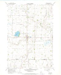
1967 Map of Cosmos
USGS Topo · Published 1968About this map
Cosmos serves as the central hub of this agricultural region in the late 1960s, situated at the junction of two primary highways. The landscape is defined by an extensive water management network of judicial and county ditches, such as Judicial Ditch No 18 and County Ditch No 23, which drain the lowlands into the South Fork Crow River and its tributary Belle Creek. This complex system of drainage infrastructure highlights the mid-century engineering required to maintain productive farmland across Danielson and Cosmos townships.
Find a feature on this map
24 named features on this map. Tap any name to fly to it.
Don’t see what you’re looking for? This feature index may not catch every label — zoom into the map to look around manually.
Map Details
Editions of this 1967 Cosmos Map
This is the sole edition of this map. No revisions or reprints were ever made.
Other maps of this area

1953 · New Ulm
USGS Topo · 1:250,000

1953 · Saint Cloud
USGS Topo · 1:250,000

1956 · Atwater
USGS Topo · 1:62,500

1957 · Saint Cloud
USGS Topo · 1:250,000

1957 · New Ulm
USGS Topo · 1:250,000

1957 · Olivia
USGS Topo · 1:62,500

1958 · New Ulm
USGS Topo · 1:250,000

1958 · Saint Cloud
USGS Topo · 1:250,000

1967 · New Ulm
USGS Topo · 1:250,000

1967 · Churchill
USGS Topo · 1:24,000