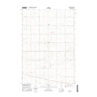
2016 Map of Olivia SE
USGS Topo · Published 2016About this map
Hydrological engineering defines the agricultural landscape of Renville County in this recent survey. A sophisticated network of man-made waterways, including Judicial Ditch Number Nine and County Ditch Number Sixtyseven, crisscrosses the township lines of t116n r33w and t115n r33w, managing the natural flow of Buffalo Cr. These ditches reflect over a century of land reclamation efforts that converted prairie wetlands into productive Minnesota farmland. For genealogists and local historians, the map preserves the locations of vital community landmarks such as the United Church of Hope Cem and Saint John's Lutheran Cem. These sites, along with the section-line roads like 870th Ave and Co Hwy 11, provide a clear framework for tracing 20th-century family farmsteads and rural development patterns.
Find a feature on this map
38 named features on this map. Tap any name to fly to it.
Don’t see what you’re looking for? This feature index may not catch every label — zoom into the map to look around manually.
Map Details
Editions of this 2016 Olivia SE Map
This is the sole edition of this map. No revisions or reprints were ever made.
Other maps of this area

1952 · Morton
USGS Topo · 1:62,500

1953 · New Ulm
USGS Topo · 1:250,000

1957 · New Ulm
USGS Topo · 1:250,000

1957 · Olivia
USGS Topo · 1:62,500

1958 · New Ulm
USGS Topo · 1:250,000

1964 · Hector
USGS Topo · 1:24,000

1967 · New Ulm
USGS Topo · 1:250,000

1967 · Churchill
USGS Topo · 1:24,000
1967 · Cosmos
USGS Topo · 1:24,000
1982 · Olivia SE
USGS Topo · 1:24,000