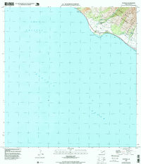
1992 Map of Olowalu
USGS Topo · Published 1999About this map
Olowalu and the surrounding coastline of West Maui appear here during the 1990s, where the narrow coastal shelf meets the steep ascent of the West Maui Forest Reserve. The map traces the vital water infrastructure that supported this landscape, including the Ukumehame Reservoir, a Siphon, and the Ukumehame Shaft (Well). Small settlements like Kilea and Mopua are situated along the shoreline, near landmarks such as Hekili Pt and the Olowalu Wharf. Inland, the terrain is dominated by the ridges of Olowalu and Ukumehame, deeply cut by the Olowalu Stream. This survey captures the specialized coastal and agricultural development of the region, where every well and spring, including the Spring near Awalua, was a critical asset for the community situated between the Auau Channel and the mountains.
Find a feature on this map
21 named features on this map. Tap any name to fly to it.
Don’t see what you’re looking for? This feature index may not catch every label — zoom into the map to look around manually.
Map Details
Editions of this 1992 Olowalu Map
This is the sole edition of this map. No revisions or reprints were ever made.
Other maps of this area

1929 · Kahoolawe
USGS Topo · 1:62,500

1954 · Maui
USGS Topo · 1:250,000

1954 · Maalaea
USGS Topo · 1:24,000

1955 · Olowalu
USGS Topo · 1:24,000

1955 · Wailuku
USGS Topo · 1:24,000

1956 · Lahaina
USGS Topo · 1:24,000

1966 · Maui
USGS Topo · 1:250,000

1974 · Maui
USGS Topo · 1:250,000

1977 · Wailuku
USGS Topo · 1:24,000
1978 · Lahaina
USGS Topo · 1:24,000