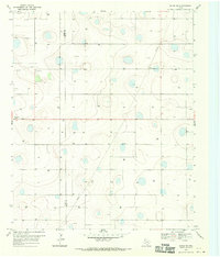
1968 Map of Olton NE
USGS Topo · Published 1970About this map
Depressions and sinkholes define the undulating High Plains landscape across the Lamb Co Hale Co boundary in the late 1960s. This agricultural terrain is characterized by a high density of groundwater infrastructure, with numerous Wells dotted throughout the quadrangle to support irrigation. Near the western edge, the Olton Cem and a small Roadside Park serve the local community on the outskirts of the nearest town center. The presence of the Olton Pumping Sta and a scattered Gravel Pit highlights the importance of resource management and local materials in this part of the Texas Panhandle. The map captures a moment when the regional economy was heavily reliant on the tapping of the Ogallala Aquifer, visible in the systematic placement of pumping sites across the section lines.
Find a feature on this map
8 named features on this map. Tap any name to fly to it.
Don’t see what you’re looking for? This feature index may not catch every label — zoom into the map to look around manually.
Map Details
Editions of this 1968 Olton NE Map
This is the sole edition of this map. No revisions or reprints were ever made.
Other maps of this area

1954 · Plainview
USGS Topo · 1:250,000

1954 · Clovis
USGS Topo · 1:250,000

1958 · Clovis
USGS Topo · 1:250,000

1958 · Plainview
USGS Topo · 1:250,000

1962 · Fieldton
USGS Topo · 1:24,000

1963 · Olton
USGS Topo · 1:24,000

1963 · Hart SW
USGS Topo · 1:24,000

1965 · Edmonson
USGS Topo · 1:24,000

1965 · Hilburn
USGS Topo · 1:24,000

1968 · Halfway
USGS Topo · 1:24,000