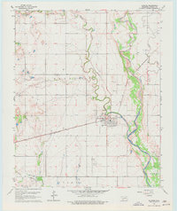
1964 Map of Olustee
USGS Topo · Published 1977About this map
Olustee serves as the central hub of this Jackson County landscape, situated where the St Louis - San Francisco railroad tracks intersect the local road network. The town layout is clearly defined, featuring a local Park and nearby Sewage Disposal Ponds along Turkey Creek. Agricultural and industrial activity is evident through several Gravel Pits and a Quarry located in the northern reaches of the survey area.
Find a feature on this map
21 named features on this map. Tap any name to fly to it.
Don’t see what you’re looking for? This feature index may not catch every label — zoom into the map to look around manually.
Map Details
Editions of this 1964 Olustee Map
2 editions found
Other maps of this area

1955 · Lawton
USGS Topo · 1:250,000

1958 · Elmer
USGS Topo · 1:62,500

1960 · Quanah
USGS Topo · 1:62,500

1963 · Altus SE
USGS Topo · 1:24,000

1964 · Martha
USGS Topo · 1:24,000

1964 · Altus
USGS Topo · 1:24,000

1964 · Olustee
USGS Topo · 1:24,000

1971 · Duke
USGS Topo · 1:24,000

1971 · Prairie Hill
USGS Topo · 1:24,000

1975 · Elmore City NE
USGS Topo · 1:24,000