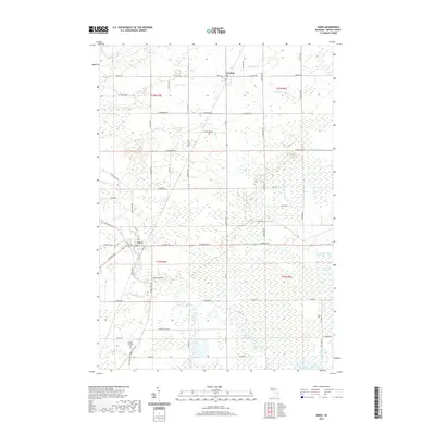
2019 Map of Omer
USGS Topo · Published 2019About this map
The Rifle River winds through the heart of this Arenac County landscape, carving a path between the settlements of Omer and Twining. This 2019 survey documents a rural Michigan environment defined by its extensive drainage network, including the Duck Lake Swamp and numerous engineered waterways like the Duck Lake Drain and Chief Cr Drain. These features speak to the region's agricultural management and the reclamation of low-lying lands. Local history is anchored by the Arenac Township Cem and the Huckle Bridge crossing, while a grid of established roads like Main St Rd and Townsend Rd connects scattered farmsteads across the township. The map provides a clear picture of the modern rural infrastructure and the persistent natural watercourses that have shaped the development of these small Michigan communities.
Find a feature on this map
67 named features on this map. Tap any name to fly to it.
Don’t see what you’re looking for? This feature index may not catch every label — zoom into the map to look around manually.
Map Details
Editions of this 2019 Omer Map
This is the sole edition of this map. No revisions or reprints were ever made.
Other maps of this area

1954 · Flint
USGS Topo · 1:250,000

1954 · Tawas City
USGS Topo · 1:250,000

1958 · Flint
USGS Topo · 1:250,000

1958 · Tawas City
USGS Topo · 1:250,000

1966 · Au Gres
USGS Topo · 1:24,000

1966 · National City
USGS Topo · 1:24,000
1967 · Standish NE
USGS Topo · 1:24,000
1967 · Standish
USGS Topo · 1:24,000

1968 · Prescott
USGS Topo · 1:24,000

1968 · Whittemore
USGS Topo · 1:24,000