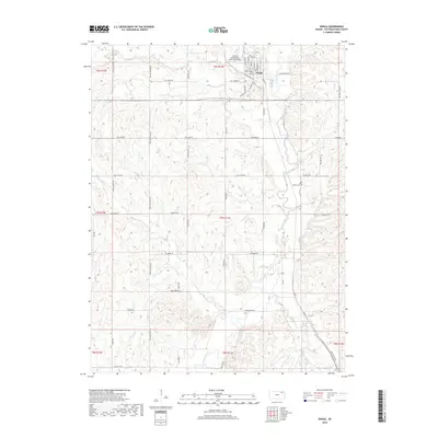
2018 Map of Onaga
USGS Topo · Published 2018About this map
Onaga serves as the primary hub of this Pottawatomie County landscape, situated where the high prairie begins to slope toward the drainage basins of Mill Cr and Vermillion Cr. The town's grid is flanked to the northwest by the Charles E Grutzmacher Municipal Airport, reflecting the modern infrastructure that connects this agricultural region. To the southeast, the Vienna Cem marks a point of local genealogical significance, situated near the winding course of Spring Cr.
Find a feature on this map
33 named features on this map. Tap any name to fly to it.
Don’t see what you’re looking for? This feature index may not catch every label — zoom into the map to look around manually.
Map Details
Editions of this 2018 Onaga Map
This is the sole edition of this map. No revisions or reprints were ever made.
Other maps of this area

1889 · Seneca
USGS Topo · 1:125,000

1889 · Wamego
USGS Topo · 1:125,000

1894 · Seneca
USGS Topo · 1:125,000

1894 · Wamego
USGS Topo · 1:125,000

1955 · Manhattan
USGS Topo · 1:250,000

1956 · Manhattan
USGS Topo · 1:250,000

1957 · Manhattan
USGS Topo · 1:250,000
1964 · Louisville
USGS Topo · 1:24,000
1964 · Onaga NE
USGS Topo · 1:24,000
1964 · Laclede
USGS Topo · 1:24,000