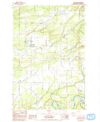
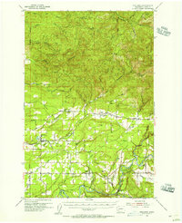
1984 Map of Onalaska
USGS Topo · Published 1993About this map
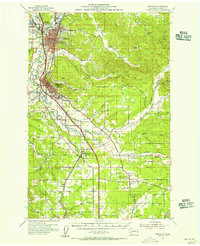
The Newaukum River watershed dominates this part of Lewis County, where the Middle, South, and main forks converge near the settlement of Onalaska. Historically a timber-driven hub, the landscape by the early 1980s is defined by a mix of agricultural clearings like Alpha Prairie and the industrial remnants of earlier eras, such as the Sewage Pond and Carlisle Lake. Farther south, the terrain descends toward the Cowlitz River, where the Barrier Dam and a local Fish Hatchery mark the management of the river's resources. Small communities like Ethel and Salkum line the southern transit corridors, while the presence of the Alpha Cem and a central High Sch point to the established local centers of this rural valley. The grid is anchored by the Willamette Meridian, which runs north-south through the western portion of the map near Cowlitz Prairie.
Find a feature on this map
47 named features on this map. Tap any name to fly to it.
Don’t see what you’re looking for? This feature index may not catch every label — zoom into the map to look around manually.
Map Details
Editions of this 1984 Onalaska Map
2 editions found
Other maps of this area

1916 · Chehalis
USGS Topo · 1:125,000

1941 · Olequa
USGS Topo · 1:62,500

1942 · Toutle
USGS Topo · 1:62,500

1943 · Willapa
USGS Topo · 1:62,500

1953 · Hoquiam
USGS Topo · 1:250,000
1953 · Toutle
USGS Topo · 1:62,500
1953 · Castle Rock
USGS Topo · 1:62,500
1954 · Onalaska
USGS Topo · 1:62,500
1954 · Centralia
USGS Topo · 1:62,500

1957 · Hoquiam
USGS Topo · 1:250,000